Geolocate

Kenyon topographic map

Click on the map to display elevation.

About this map

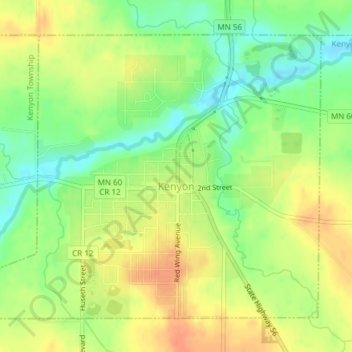
Name: Kenyon topographic map, elevation, terrain.

Location: Kenyon, Goodhue County, Minnesota, United States (44.26202 -93.00557 44.28378 -92.96996)

Average elevation: 1,152 ft

Minimum elevation: 1,076 ft

Maximum elevation: 1,217 ft

Goodhue County trails, hiking, mountain biking, running and outdoor activities

Other topographic maps

Click on a map to view its topography, its elevation and its terrain.

Frontenac

United States > Minnesota > Goodhue County

Average elevation: 797 ft

Frontenac

United States > Minnesota > Goodhue County

Average elevation: 797 ft

Woodbury WMA

United States > Minnesota > Goodhue County > Zumbrota

Average elevation: 1,119 ft

Welch

United States > Minnesota > Goodhue County > Welch Township

Average elevation: 909 ft

Gear up for your next adventure:

🪶Thermal Camp Blanket - Extra warmth for cold nights
Solar GPS Watches - Advanced multisport watches with built-in topographic maps
📷Action Camera - Capture your outdoor adventures in HD
🧦Merino Wool Socks - Moisture-wicking, blister-preventing socks for long treks
🌐World Map Poster - Decorative world maps with topographic info

As an Amazon Associate, this site earns from qualifying purchases at no extra cost to you.