Geolocate
👉 Easily get elevation data in JSON, GeoTIFF and KML formats using Elevation API
Thank you for supporting this site ❤️
Make a donation

Caribou topographic map

Click on the map to display elevation.

About this map

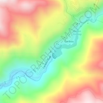
Name: Caribou topographic map, elevation, terrain.

Location: Caribou, Plumas County, California, United States (40.06942 -121.17048 40.08473 -121.15125)

Average elevation: 3,835 ft

Minimum elevation: 2,789 ft

Maximum elevation: 5,039 ft

Plumas County trails, hiking, mountain biking, running and outdoor activities

Other topographic maps

Click on a map to view its topography, its elevation and its terrain.

Chester

United States > California > Plumas County

Average elevation: 4,564 ft

Graeagle

United States > California > Plumas County

Average elevation: 4,570 ft

Quincy

United States > California > Plumas County

Quincy has a Mediterranean climate (Köppen Csb) though its inland location and altitude makes it more continental and wetter than usual for this type, with very heavy snowfalls sometimes occurring in winter – the record being 133 inches (337.8 cm) in the very wet January 1916. Although summer days are hot…

Average elevation: 4,180 ft

Meadow Valley

United States > California > Plumas County

Average elevation: 4,957 ft

East Quincy

United States > California > Plumas County

East-Quincy has a Mediterranean climate (Köppen Csb) though its inland location and altitude makes it more continental and wetter than usual for this type, with very heavy snowfalls sometimes occurring in winter – the record being 133 inches (337.8 cm) in the very wet January 1916. Although summer days are…

Average elevation: 3,671 ft

Chimney Rock

United States > California > Plumas County

Average elevation: 5,492 ft

Swain Mountain

United States > California > Plumas County

Average elevation: 6,526 ft

Beckwourth Peak

United States > California > Plumas County

Average elevation: 6,109 ft

Mount Elwell

United States > California > Plumas County

Average elevation: 6,762 ft

Gear up for your next adventure:

🪶Wildlife Field Guides - Learn animal tracking and species ID
🎒Outdoor Daypacks - Lightweight backpacks designed for carrying maps and essential gear
🚗GPS Dash Cams - Record your scenic drives through mountain passes and canyons
Solar GPS Watches - Advanced multisport watches with built-in topographic maps
🎒Waterproof Dry Bags - Keep your electronics and maps dry inside your pack

As an Amazon Associate, this site earns from qualifying purchases at no extra cost to you.