
Thank you for supporting this site ❤️
Make a donation
Make a donation
Gear up for your next adventure:
As an Amazon Associate, this site earns from qualifying purchases at no extra cost to you.
Lapurerreketa topographic map
Click on the map to display elevation.
Thank you for supporting this site ❤️
Make a donation
Make a donation
Gear up for your next adventure:
As an Amazon Associate, this site earns from qualifying purchases at no extra cost to you.
About this map
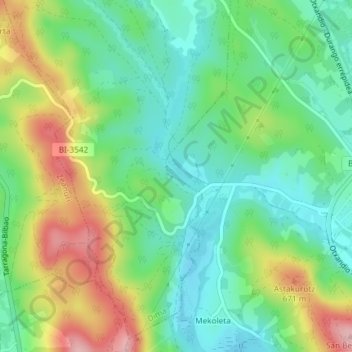
Name: Lapurerreketa topographic map, elevation, terrain.
Location: Lapurerreketa, Dima, Vizcaya, País Vasco, 48141, España (43.04461 -2.67691 43.04728 -2.67335)
Average elevation: 1,959 ft
Minimum elevation: 1,772 ft
Maximum elevation: 2,293 ft
Thank you for supporting this site ❤️
Make a donation
Make a donation
Gear up for your next adventure:
As an Amazon Associate, this site earns from qualifying purchases at no extra cost to you.
Other topographic maps
Click on a map to view its topography, its elevation and its terrain.