
Rosamond topographic map
Click on the map to display elevation.
Rosamond
Rosamond sits in the northern end of the Antelope Valley, the westernmost valley of the Mojave Desert. Because the elevation is 2,000 to 3,000 feet (610 to 910 m) above sea level, the area, like the other parts of the Mojave Desert region, is referred to as the High Desert. Some cities and communities within the trading area of Rosamond include Lancaster, Palmdale, Hi Vista, Roosevelt, Redman, Lake Los Angeles, Quartz Hill, Ridgecrest, and Santa Clarita. Residents of these desert cities and unincorporated communities share Sierra Highway, Angeles Forest Highway, Angeles Crest Highway (State Route 2), and the Antelope Valley Freeway (State Route 14) for commutes to the San Fernando Valley and Los Angeles Basin in order to get to work.
About this map
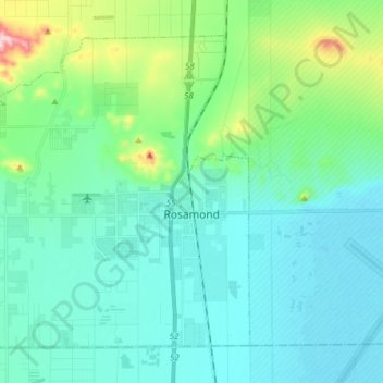
Name: Rosamond topographic map, elevation, terrain.
Location: Rosamond, Kern County, California, 93560, United States (34.81995 -118.29364 34.92294 -118.14007)
Average elevation: 2,457 ft
Minimum elevation: 2,267 ft
Maximum elevation: 3,317 ft
Kern County trails, hiking, mountain biking, running and outdoor activities