Geolocate

Monte Nebin (Cima SE) topographic map

Click on the map to display elevation.

About this map

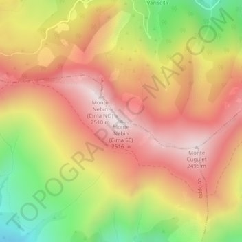
Name: Monte Nebin (Cima SE) topographic map, elevation, terrain.

Location: Monte Nebin (Cima SE), Sampeyre, Cuneo, Piemonte, Italia (44.54013 7.14896 44.54023 7.14906)

Average elevation: 6,985 ft

Minimum elevation: 5,318 ft

Maximum elevation: 8,205 ft

Gear up for your next adventure:

🔋Solar Power Banks - Keep your GPS and phone charged in remote wilderness areas
🦶Carbon Trekking Poles - Reduce knee impact on steep descents with ultra-light poles
🥄Camping Utensil Set - Lightweight utensils for outdoor meals
📖Nature Tracking Books - Learn to track wildlife and terrain
🔦Compact Flashlight - Reliable flashlight for emergencies

As an Amazon Associate, this site earns from qualifying purchases at no extra cost to you.