
Make a donation
Gear up for your next adventure:
As an Amazon Associate, this site earns from qualifying purchases at no extra cost to you.
Zauckerode topographic map
Click on the map to display elevation.
Make a donation
Gear up for your next adventure:
As an Amazon Associate, this site earns from qualifying purchases at no extra cost to you.
About this map
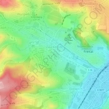
Name: Zauckerode topographic map, elevation, terrain.
Average elevation: 732 ft
Minimum elevation: 535 ft
Maximum elevation: 1,040 ft
Make a donation
Gear up for your next adventure:
As an Amazon Associate, this site earns from qualifying purchases at no extra cost to you.
Other topographic maps
Click on a map to view its topography, its elevation and its terrain.
Windberg
Deutschland > Sachsen > Sächsische Schweiz-Osterzgebirge > Freital
Der Aufstieg von Süden aus Richtung Niederhäslich und von Norden aus Richtung Burgk führt jeweils über steile Wanderwege durch Buchen-, dabei insbesondere Hainbuchen- und Eichenwald hinauf. Von Osten aus Richtung Bannewitz gelangt man ohne die Überwindung größerer Höhenunterschiede zum…
Average elevation: 830 ft
Eckersdorf
Deutschland > Sachsen > Sächsische Schweiz-Osterzgebirge > Freital
Average elevation: 945 ft