
Make a donation
Gear up for your next adventure:
As an Amazon Associate, this site earns from qualifying purchases at no extra cost to you.
Monte Faro topographic map
Click on the map to display elevation.
Make a donation
Gear up for your next adventure:
As an Amazon Associate, this site earns from qualifying purchases at no extra cost to you.
About this map
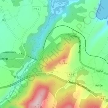
Name: Monte Faro topographic map, elevation, terrain.
Location: Monte Faro, Valdés, Asturias, 37790, España (43.53691 -6.62856 43.55691 -6.60856)
Average elevation: 364 ft
Minimum elevation: 0 ft
Maximum elevation: 1,040 ft
Make a donation
Gear up for your next adventure:
As an Amazon Associate, this site earns from qualifying purchases at no extra cost to you.
Other topographic maps
Click on a map to view its topography, its elevation and its terrain.
Carcedo
Carcedo (Carcéu en asturiano y oficialmente) pueblo y parroquia del concejo asturiano de Valdés, en España, situado a unos 23 kilómetros de Luarca y a unos 85 de Oviedo. El pueblo de Carcedo, está situado a una altitud de 240 metros sobre el nivel del mar, tiene una población de unos 115 habitantes…
Average elevation: 643 ft