
Bretnig-Hauswalde topographic map
Interactive map
Click on the map to display elevation.
About this map
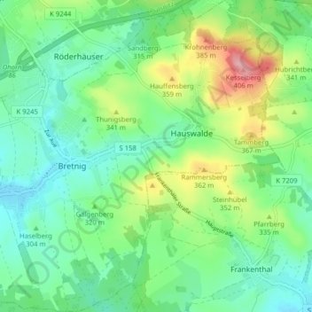
Name: Bretnig-Hauswalde topographic map, elevation, terrain.
Location: Bretnig-Hauswalde, Großröhrsdorf, Bautzen, Saxony, Germany (51.12422 14.04323 51.17359 14.11331)
Average elevation: 1,040 ft
Minimum elevation: 909 ft
Maximum elevation: 1,342 ft
Other topographic maps
Click on a map to view its topography, its elevation and its terrain.
Bretnig
Germany > Saxony > Großröhrsdorf
Bretnig, Bretnig-Hauswalde, Großröhrsdorf, Bautzen, Saxony, 01900, Germany
Average elevation: 1,004 ft