
Make a donation
Gear up for your next adventure:
As an Amazon Associate, this site earns from qualifying purchases at no extra cost to you.
Birgelen topographic map
Click on the map to display elevation.
Make a donation
Gear up for your next adventure:
As an Amazon Associate, this site earns from qualifying purchases at no extra cost to you.
Birgelen
Auf der Topographischen Karte 1:50.000, Blatt L4902 Heinsberg, 6. Auflage 1983, wurden die Ortsnamen Birgelen (eigentlich bei Wassenberg) und Birgden (eigentlich bei Gangelt) vertauscht.
Make a donation
Gear up for your next adventure:
As an Amazon Associate, this site earns from qualifying purchases at no extra cost to you.
About this map
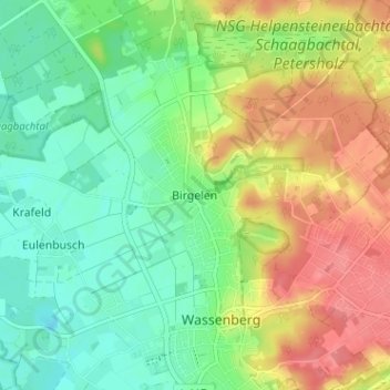
Name: Birgelen topographic map, elevation, terrain.
Average elevation: 184 ft
Minimum elevation: 89 ft
Maximum elevation: 318 ft
Make a donation
Gear up for your next adventure:
As an Amazon Associate, this site earns from qualifying purchases at no extra cost to you.
Other topographic maps
Click on a map to view its topography, its elevation and its terrain.
41849
Deutschland > Nordrhein-Westfalen > Kreis Heinsberg > Wassenberg > Eulenbusch
Average elevation: 138 ft