
Cong topographic map
Click on the map to display elevation.
About this map
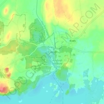
Name: Cong topographic map, elevation, terrain.
Average elevation: 75 ft
Minimum elevation: 3 ft
Maximum elevation: 226 ft
Other topographic maps
Click on a map to view its topography, its elevation and its terrain.
Killala
The Roman Catholic Diocese of Killala (Alladenis in Latin) is one of the five suffragan sees of the ecclesiastical Province of Tuam, comprising the north-western part of the County Mayo with the Barony of Tireragh in the County Sligo. In all there are 22 parishes, some of which, bordering on the Atlantic…
Average elevation: 69 ft
Westport
The first clear evidence for the development of the new town is in an advertisement in Faulkner's Dublin Journal on March 17, 1767, stating 'a New Town is immediately to be built near the old town of Westport...according to Plans and Elevations already prepared'. The focal point was to be a 'large and elegant…
Average elevation: 144 ft