Geolocate

Lavasan topographic map

Click on the map to display elevation.

About this map
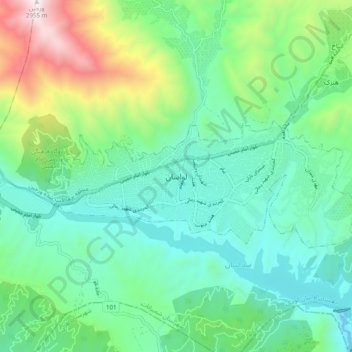
Name: Lavasan topographic map, elevation, terrain.

Location: Lavasan, Lavasanat, Shemiranat County, Tehran Province, 33416-81979, Iran (35.78048 51.59214 35.86048 51.67214)

Average elevation: 6,234 ft

Minimum elevation: 5,020 ft

Maximum elevation: 9,695 ft

Other topographic maps

Click on a map to view its topography, its elevation and its terrain.
Niavaran

Iran > Tehran Province > Shemiranat County > Tehran

Average elevation: 5,919 ft

Niavaran

Iran > Tehran Province > Shemiranat County > Tehran

Average elevation: 5,604 ft

Tajrish

Iran > Tehran Province > Shemiranat County

Average elevation: 6,198 ft

Niyavaran Park

Iran > Tehran Province > Shemiranat County > Tehran

Average elevation: 5,361 ft

Jamshidieh Park

Iran > Tehran Province > Shemiranat County > Tehran

Average elevation: 6,506 ft

Gear up for your next adventure:

🦟Ultrasonic Repellers - Create a bug-free zone at your camp or rest stop
🎒Trekking Poles - Sturdy poles for balance and stability on rough terrain
🧣Hiking Neck Gaiter - Multi‑use neck protection for outdoor weather
🔭Compact Binoculars - HD vision for scouting terrain and identifying distant landmarks
👖Convertible Hiking Pants - Versatile zip-off pants for changing altitudes and temperatures

As an Amazon Associate, this site earns from qualifying purchases at no extra cost to you.