Geolocate

Epagny topographic map

Click on the map to display elevation.

About this map
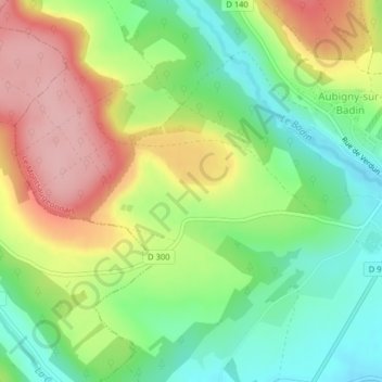
Name: Epagny topographic map, elevation, terrain.

Location: Epagny, Vaux-sous-Aubigny, Le Montsaugeonnais, Langres, Haute-Marne, Grand Est, France métropolitaine, 52190, France (47.64661 5.25415 47.66661 5.27415)

Average elevation: 1,119 ft

Minimum elevation: 902 ft

Maximum elevation: 1,391 ft

Other topographic maps

Click on a map to view its topography, its elevation and its terrain.
Montsaugeon

France > Grand Est > Haute-Marne > Le Montsaugeonnais

Montsaugeon est situé sur l'ancien pagus bourguigon de l'Attouar ou de l'Atuyer qui est resté un lieu de passage antique entre les vallées du Rhône et du Rhin, une espèce de col à 338 mètres d'altitude entre les deux mers, enjeu de luttes et d'incursions stratégiques qui provoquèrent la construction…

Average elevation: 971 ft

Prauthoy

France > Grand Est > Haute-Marne > Le Montsaugeonnais

Average elevation: 1,093 ft

Gear up for your next adventure:

🩳Quick‑Dry Hiking Shorts - Comfortable and quick‑dry shorts for summer hiking
🦶Carbon Trekking Poles - Reduce knee impact on steep descents with ultra-light poles
😴Insulated Sleeping Pads - Compact and warm pads for high-elevation camping
🎒Waterproof Dry Bags - Keep your electronics and maps dry inside your pack
🛶Inflatable Kayak - Portable kayak for rivers, lakes, and expeditions

As an Amazon Associate, this site earns from qualifying purchases at no extra cost to you.