
Make a donation
Gear up for your next adventure:
As an Amazon Associate, this site earns from qualifying purchases at no extra cost to you.
Arrecife topographic map
Click on the map to display elevation.
Make a donation
Gear up for your next adventure:
As an Amazon Associate, this site earns from qualifying purchases at no extra cost to you.
About this map
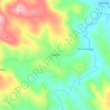
Name: Arrecife topographic map, elevation, terrain.
Average elevation: 1,837 ft
Minimum elevation: 1,581 ft
Maximum elevation: 2,215 ft
Make a donation
Gear up for your next adventure:
As an Amazon Associate, this site earns from qualifying purchases at no extra cost to you.
Other topographic maps
Click on a map to view its topography, its elevation and its terrain.
Brumado
Sua área territorial é de 2 207,612 km² quilômetros quadrados, sendo a área da sede de 2 174 km², a uma altitude de 454 metros. O Índice de Desenvolvimento Humano (IDH) é 0,656 (médio). Um levantamento feito pela Federação das Indústrias do Estado do Rio de Janeiro (FIRJAN) constatou que Brumado é…
Average elevation: 1,781 ft