Geolocate

Mittweida topographic map

Click on the map to display elevation.

About this map
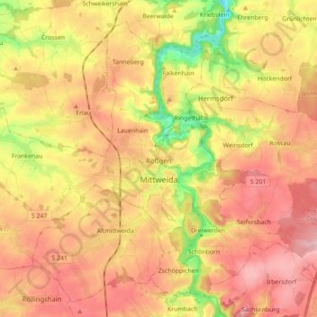
Name: Mittweida topographic map, elevation, terrain.

Location: Mittweida, Mittelsachsen, Saxony, 09648, Germany (50.94498 12.86708 51.04033 13.04154)

Average elevation: 971 ft

Minimum elevation: 640 ft

Maximum elevation: 1,207 ft

Other topographic maps

Click on a map to view its topography, its elevation and its terrain.

Rosine

Germany > Saxony > Mittelsachsen > Freiberg

Average elevation: 1,378 ft

Ullersdorf

Germany > Saxony > Mittelsachsen > Sayda

Average elevation: 2,113 ft

Clausnitz

Germany > Saxony > Mittelsachsen

Average elevation: 1,998 ft

Holzhau

Germany > Saxony > Mittelsachsen

Average elevation: 2,379 ft

Seifersdorf

Germany > Saxony > Mittelsachsen > Hartha

Average elevation: 814 ft

Dittmannsdorf

Germany > Saxony > Mittelsachsen > Penig

Average elevation: 820 ft

Erdmannsdorf

Germany > Saxony > Mittelsachsen > Augustusburg

Average elevation: 1,234 ft

Tuttendorf

Germany > Saxony > Mittelsachsen

Average elevation: 1,234 ft

Gear up for your next adventure:

🥇GPS Hiking Watch - Multi‑sport GPS watch with navigation and trail tracking
🥾Men's Hiking Boots - Durable, waterproof footwear for rugged terrain and steep inclines
🔊Portable Camp Speaker - Music and alerts at camp
🧢Outdoor Hiking Hat - Sun protection hat for outdoor explorers
🔥Camping Stove - Portable stove for camping and backcountry cooking

As an Amazon Associate, this site earns from qualifying purchases at no extra cost to you.