
Water Island topographic map
Click on the map to display elevation.
About this map
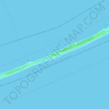
Name: Water Island topographic map, elevation, terrain.
Average elevation: 0 ft
Minimum elevation: -3 ft
Maximum elevation: 26 ft
Suffolk County trails, hiking, mountain biking, running and outdoor activities
Other topographic maps
Click on a map to view its topography, its elevation and its terrain.
Port Jefferson Harbor
United States > New York > Suffolk County > Town of Brookhaven
Average elevation: 33 ft
Village of Belle Terre
United States > New York > Suffolk County > Town of Brookhaven
Average elevation: 66 ft
Middle Island
United States > New York > Suffolk County > Town of Brookhaven
On October 27, 1910, the International Aviation Tournament was held at the Belmont Park racetrack in Elmont, New York. The meet offered $3,750 for the highest altitude, another $1,000 for a world record and a $5,000 bonus for exceeding 10,000 feet. Ralph Johnstone set a new American flight altitude record of…
Average elevation: 102 ft