
Make a donation
Gear up for your next adventure:
As an Amazon Associate, this site earns from qualifying purchases at no extra cost to you.
Chanxhe topographic map
Click on the map to display elevation.
Make a donation
Gear up for your next adventure:
As an Amazon Associate, this site earns from qualifying purchases at no extra cost to you.
About this map
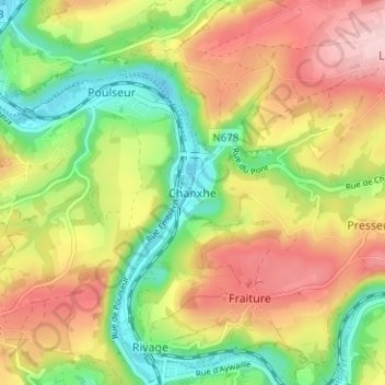
Name: Chanxhe topographic map, elevation, terrain.
Location: Chanxhe, Sprimont, Liège, Wallonie, 1771, Belgique (50.47935 5.57556 50.51935 5.61556)
Average elevation: 600 ft
Minimum elevation: 285 ft
Maximum elevation: 942 ft
Make a donation
Gear up for your next adventure:
As an Amazon Associate, this site earns from qualifying purchases at no extra cost to you.
Other topographic maps
Click on a map to view its topography, its elevation and its terrain.
Dolembreux
Belgique > Liège > Liège > Sprimont
Dolembreux est un village de la province de Liège qui se situe dans le nord-ouest de la commune de Sprimont. Sa superficie est de 1080 ha. En plus du village principal, Dolembreux se compose de plusieurs hameaux, avec Betgné, Hautgné et Hayen qui se situent à l’ouest. La bordure nord du village, avec…
Average elevation: 778 ft
Make a donation
Gear up for your next adventure:
As an Amazon Associate, this site earns from qualifying purchases at no extra cost to you.
Louveigné
Belgique > Liège > Liège > Sprimont
Le village de Louveigné se situe à une altitude de 260 mètres environ, sur la ligne de partage entre l'Amblève et la Vesdre, à la limite nord du vallon des chantoirs et de la région calcaire de la Calestienne ainsi qu'à la limite est du Condroz liégeois. Quant à l'Ardenne, elle occupe la partie…
Average elevation: 883 ft
Louveigné
Belgique > Liège > Liège > Sprimont
Le village de Louveigné se situe à une altitude de 260 mètres environ, sur la ligne de partage entre l'Amblève et la Vesdre, à la limite nord du vallon des chantoirs et de la région calcaire de la Calestienne ainsi qu'à la limite est du Condroz liégeois. Quant à l'Ardenne, elle occupe la partie…
Average elevation: 866 ft