
Thank you for supporting this site ❤️
Make a donation
Make a donation
Gear up for your next adventure:
As an Amazon Associate, this site earns from qualifying purchases at no extra cost to you.
Fragno topographic map
Click on the map to display elevation.
Thank you for supporting this site ❤️
Make a donation
Make a donation
Gear up for your next adventure:
As an Amazon Associate, this site earns from qualifying purchases at no extra cost to you.
About this map
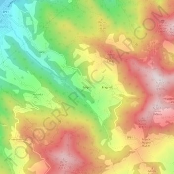
Name: Fragno topographic map, elevation, terrain.
Location: Fragno, Calestano, Parma, Emilia-Romagna, Italia (44.56681 10.13117 44.60681 10.17117)
Average elevation: 2,441 ft
Minimum elevation: 1,243 ft
Maximum elevation: 3,517 ft
Thank you for supporting this site ❤️
Make a donation
Make a donation
Gear up for your next adventure:
As an Amazon Associate, this site earns from qualifying purchases at no extra cost to you.