
Make a donation
Gear up for your next adventure:
As an Amazon Associate, this site earns from qualifying purchases at no extra cost to you.
Bühlingen topographic map
Click on the map to display elevation.
Make a donation
Gear up for your next adventure:
As an Amazon Associate, this site earns from qualifying purchases at no extra cost to you.
Bühlingen
In Rottweil steht der 246 Meter hohe TK-Elevator-Testturm, der weltweit zweithöchste Testturm für Aufzugsanlagen. Die Konstruktion dient dem Test und der Zertifizierung von Hochgeschwindigkeitsaufzügen. Die öffentliche Besucherplattform auf 232 Meter Höhe ist die höchste Besucherplattform Deutschlands. Der Turm wurde von 2014 bis 2017 von der ThyssenKrupp Elevator AG errichtet. Das Design des Turmes stammt von dem Architekten Helmut Jahn.
Make a donation
Gear up for your next adventure:
As an Amazon Associate, this site earns from qualifying purchases at no extra cost to you.
About this map
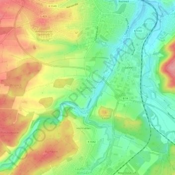
Name: Bühlingen topographic map, elevation, terrain.
Average elevation: 1,998 ft
Minimum elevation: 1,818 ft
Maximum elevation: 2,228 ft
Make a donation
Gear up for your next adventure:
As an Amazon Associate, this site earns from qualifying purchases at no extra cost to you.
Other topographic maps
Click on a map to view its topography, its elevation and its terrain.
Feckenhausen
Deutschland > Baden-Württemberg > Landkreis Rottweil > Rottweil
Average elevation: 2,185 ft
Hausen
Deutschland > Baden-Württemberg > Landkreis Rottweil > Rottweil
In Rottweil steht der 246 Meter hohe TK-Elevator-Testturm, der weltweit zweithöchste Testturm für Aufzugsanlagen. Die Konstruktion dient dem Test und der Zertifizierung von Hochgeschwindigkeitsaufzügen. Die öffentliche Besucherplattform auf 232 Meter Höhe ist die höchste Besucherplattform Deutschlands.…
Average elevation: 2,169 ft