
Make a donation
Gear up for your next adventure:
As an Amazon Associate, this site earns from qualifying purchases at no extra cost to you.
Diedorf topographic map
Click on the map to display elevation.
Make a donation
Gear up for your next adventure:
As an Amazon Associate, this site earns from qualifying purchases at no extra cost to you.
About this map
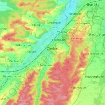
Name: Diedorf topographic map, elevation, terrain.
Location: Diedorf, Augsburg (district), Bavaria, 86420, Germany (48.30416 10.71166 48.39672 10.80609)
Average elevation: 1,660 ft
Minimum elevation: 1,493 ft
Maximum elevation: 1,890 ft
Make a donation
Gear up for your next adventure:
As an Amazon Associate, this site earns from qualifying purchases at no extra cost to you.
Other topographic maps
Click on a map to view its topography, its elevation and its terrain.
Leuthau
Germany > Bavaria > Augsburg (district) > Schwabmünchen > Klimmach
Average elevation: 1,893 ft
Westendorf
Germany > Bavaria > Augsburg (district) > Westendorf > Westendorf
Average elevation: 1,430 ft