
Grand River topographic map
Interactive map
Click on the map to display elevation.
About this map
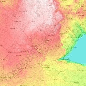
Name: Grand River topographic map, elevation, terrain.
Average elevation: 984 ft
Minimum elevation: 230 ft
Maximum elevation: 1,726 ft
Other topographic maps
Click on a map to view its topography, its elevation and its terrain.
Peterborough
Canadá > Ontario > Peterborough
Peterborough, Central Ontario, Ontario, K9H 7E8, Canadá
Average elevation: 771 ft
Richmond Hill
Canadá > Ontario > Richmond Hill
Richmond Hill, York Region, Golden Horseshoe, Ontario, Canadá
Average elevation: 840 ft
Carleton Place
Canadá > Ontario > Carleton Place
Carleton Place, Lanark County, Eastern Ontario, Ontario, Canadá
Average elevation: 449 ft
Victoria Island
Victoria Island, (Old) Ottawa, Ottawa, Ontario, K1R 1C5, Canadá
Average elevation: 413 ft
Manitoulin Island
Canadá > Ontario > Northeastern Manitoulin and the Islands
Manitoulin Island, Northeastern Manitoulin and the Islands, Manitoulin District, Ontario, Canadá
Average elevation: 663 ft
Lago Nipigon
Canadá > Ontario > Unorganized Thunder Bay District
Lago Nipigon, Unorganized Thunder Bay District, Thunder Bay District, Northwestern Ontario, Ontario, Canadá
Average elevation: 1,007 ft
Lago Hurón
Lago Hurón, Southwestern Ontario, Ontario, Canadá
Average elevation: 755 ft
Windermere Lake
Canadá > Ontario > Unorganized South Nipissing
Windermere Lake, Unorganized South Nipissing, Nipissing District, Ontario, Canadá
Average elevation: 1,165 ft
Thunder Bay District
Thunder Bay District, Ontario, Canadá
Average elevation: 1,027 ft
Lake Simcoe
Canadá > Ontario > Oro-Medonte
Lake Simcoe, Oro-Medonte, Simcoe County, Central Ontario, Ontario, L3Y 7C1, Canadá
Average elevation: 810 ft
Lago de los Bosques
Canadá > Ontario > Lake of the Woods
Lago de los Bosques, Lake of the Woods, Rainy River District, Northwestern Ontario, Ontario, P0X 1C0, Canadá
Average elevation: 1,106 ft
Lago Ontario
Canadá > Ontario > Quinte West
Lago Ontario, Quinte West, Central Ontario, Ontario, Canadá
Average elevation: 705 ft