Geolocate

Howland topographic map

Click on the map to display elevation.

About this map

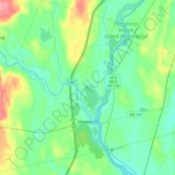
Name: Howland topographic map, elevation, terrain.

Location: Howland, Penobscot County, Maine, 04448, United States (45.20204 -68.77606 45.32215 -68.62557)

Average elevation: 200 ft

Minimum elevation: 121 ft

Maximum elevation: 400 ft

Penobscot County trails, hiking, mountain biking, running and outdoor activities

Other topographic maps

Click on a map to view its topography, its elevation and its terrain.

Bangor Hill

United States > Maine > Penobscot County > Orono

Average elevation: 203 ft

Hudson Hill

United States > Maine > Penobscot County > Hudson

Average elevation: 253 ft

Blackcap

United States > Maine > Penobscot County > Eddington

Average elevation: 571 ft

Sugar Island

United States > Maine > Penobscot County > Greenbush

Average elevation: 135 ft

Tiger Rips

United States > Maine > Penobscot County

Average elevation: 741 ft

State Island

United States > Maine > Penobscot County

Average elevation: 482 ft

Lincoln

United States > Maine > Penobscot County > Lincoln

Average elevation: 272 ft

Gear up for your next adventure:

🛰️Satellite Messengers - Emergency SOS and two-way messaging for off-grid adventures
🔌USB Car Charger - Car charger for on‑the‑go power needs
❄️Traction Cleats - Prevent slips on icy trails during winter hikes
🧣Merino Neck Gaiters - Multi-functional headwear for wind and sun protection
🛡️Insect Repellent - Protection against bugs during outdoor activities

As an Amazon Associate, this site earns from qualifying purchases at no extra cost to you.