Geolocate

Dolnja Briga topographic map

Click on the map to display elevation.

About this map

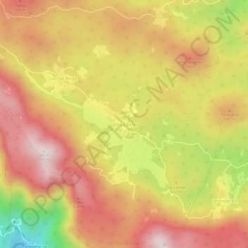
Name: Dolnja Briga topographic map, elevation, terrain.

Location: Dolnja Briga, Kočevje, 1336, Slovenia (45.50266 14.79911 45.54266 14.83911)

Average elevation: 2,113 ft

Minimum elevation: 814 ft

Maximum elevation: 2,972 ft

Gear up for your next adventure:

Solar GPS Watches - Advanced multisport watches with built-in topographic maps
🎒Gear Packing Cubes - Organize your backpack efficiently
🪶Survival Guide Book - Expert advice for emergency preparedness
GPS Sports Watch - GPS watch for running, hiking and training
🛡️Bear Spray Outdoor - Protection in bear country hikes

As an Amazon Associate, this site earns from qualifying purchases at no extra cost to you.