
Make a donation
Gear up for your next adventure:
As an Amazon Associate, this site earns from qualifying purchases at no extra cost to you.
Cerro Uritorco topographic map
Click on the map to display elevation.
Make a donation
Gear up for your next adventure:
As an Amazon Associate, this site earns from qualifying purchases at no extra cost to you.
Cerro Uritorco
El Uritorco (uritu urqu = "cerro de los loros" en quichua) es un cerro de 1979 m s. n. m. (unos 6500 pies) en el centro de la Argentina, situado en el norte del Valle de Punilla, en Capilla del Monte, en la provincia de Córdoba, accesible por las rutas RN 38 y provincial 17. Su cumbre es la máxima elevación de la Sierras Chicas, llamada antiguamente Viarava. Es considerada la sexta Maravilla Natural de Córdoba.
Make a donation
Gear up for your next adventure:
As an Amazon Associate, this site earns from qualifying purchases at no extra cost to you.
About this map
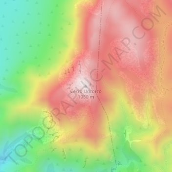
Name: Cerro Uritorco topographic map, elevation, terrain.
Average elevation: 5,154 ft
Minimum elevation: 3,773 ft
Maximum elevation: 6,335 ft
Make a donation
Gear up for your next adventure:
As an Amazon Associate, this site earns from qualifying purchases at no extra cost to you.
Other topographic maps
Click on a map to view its topography, its elevation and its terrain.
Faldas del Uritorco
Argentina > Córdoba > Pedanía Dolores > Capilla del Monte
Average elevation: 3,474 ft
Make a donation
Gear up for your next adventure:
As an Amazon Associate, this site earns from qualifying purchases at no extra cost to you.
Make a donation
Gear up for your next adventure:
As an Amazon Associate, this site earns from qualifying purchases at no extra cost to you.