Geolocate

Springville topographic map

Click on the map to display elevation.

About this map

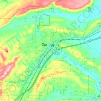
Name: Springville topographic map, elevation, terrain.

Location: Springville, St. Clair County, Alabama, 35146, United States (33.72166 -86.51653 33.81584 -86.38997)

Average elevation: 883 ft

Minimum elevation: 617 ft

Maximum elevation: 1,480 ft

St. Clair County trails, hiking, mountain biking, running and outdoor activities

Other topographic maps

Click on a map to view its topography, its elevation and its terrain.

Parsons

United States > Alabama > St. Clair County > Moody > Parsons

Average elevation: 702 ft

Cropwell

United States > Alabama > St. Clair County > Pell City

Average elevation: 509 ft

Cook Springs

United States > Alabama > St. Clair County

Average elevation: 728 ft

Ragland

United States > Alabama > St. Clair County

Average elevation: 607 ft

Gear up for your next adventure:

🔊Portable Camp Speaker - Music and alerts at camp
🪄Magnetic Compass - Accurate compass for navigation
🔭Telescopic Hiking Pole - Adjustable pole for hiking stability
🪵Folding Camp Saw - Compact saw for wood and campsite work
🧭Outdoor Navigation Book - Learn advanced navigation skills

As an Amazon Associate, this site earns from qualifying purchases at no extra cost to you.