
Thank you for supporting this site ❤️
Make a donation
Make a donation
Gear up for your next adventure:
As an Amazon Associate, this site earns from qualifying purchases at no extra cost to you.
Palanzo topographic map
Click on the map to display elevation.
Thank you for supporting this site ❤️
Make a donation
Make a donation
Gear up for your next adventure:
As an Amazon Associate, this site earns from qualifying purchases at no extra cost to you.
About this map
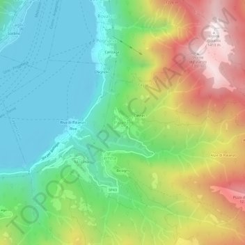
Name: Palanzo topographic map, elevation, terrain.
Location: Palanzo, Faggeto Lario, Como, Lombardia, 22020, Italia (45.84497 9.14251 45.88497 9.18251)
Average elevation: 2,083 ft
Minimum elevation: 623 ft
Maximum elevation: 4,613 ft
Thank you for supporting this site ❤️
Make a donation
Make a donation
Gear up for your next adventure:
As an Amazon Associate, this site earns from qualifying purchases at no extra cost to you.