
Make a donation
Gear up for your next adventure:
As an Amazon Associate, this site earns from qualifying purchases at no extra cost to you.
Parque Nacional Llanganates topographic map
Click on the map to display elevation.
Make a donation
Gear up for your next adventure:
As an Amazon Associate, this site earns from qualifying purchases at no extra cost to you.
Parque Nacional Llanganates
In 2013, explorers from Ecuador, Britain, France, and America discovered and unearthed a 260 ft tall by 260 ft wide structure, made up of hundreds of two-ton stone blocks, and believe there could be more, similar constructions over an area of about a square mile. The area is 20 miles from the town of Baños but the trek takes around eight hours through swampy and mountainous jungle. The area of discovery is at an altitude of 8,500 ft above sea level and in cloud forest.
Make a donation
Gear up for your next adventure:
As an Amazon Associate, this site earns from qualifying purchases at no extra cost to you.
About this map
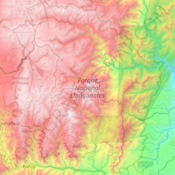
Name: Parque Nacional Llanganates topographic map, elevation, terrain.
Location: Parque Nacional Llanganates, Napo, Ecuador (-1.42600 -78.47977 -0.85497 -77.98276)
Average elevation: 8,734 ft
Minimum elevation: 1,916 ft
Maximum elevation: 14,698 ft
Make a donation
Gear up for your next adventure:
As an Amazon Associate, this site earns from qualifying purchases at no extra cost to you.
Other topographic maps
Click on a map to view its topography, its elevation and its terrain.
Make a donation
Gear up for your next adventure:
As an Amazon Associate, this site earns from qualifying purchases at no extra cost to you.