Geolocate

Lowesville topographic map

Click on the map to display elevation.

About this map

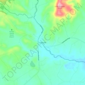
Name: Lowesville topographic map, elevation, terrain.

Location: Lowesville, Nelson County, Virginia, 24512, United States (37.69903 -79.08475 37.73903 -79.04475)

Average elevation: 823 ft

Minimum elevation: 663 ft

Maximum elevation: 1,280 ft

Nelson County trails, hiking, mountain biking, running and outdoor activities

Other topographic maps

Click on a map to view its topography, its elevation and its terrain.

Wintergreen

United States > Virginia > Nelson County > Wintergreen

Average elevation: 2,310 ft

Afton

United States > Virginia > Nelson County > Afton

Average elevation: 1,155 ft

Nellysford

United States > Virginia > Nelson County > Nellysford

Average elevation: 1,302 ft

Lovingston

United States > Virginia > Nelson County > Lovingston

Average elevation: 1,037 ft

Schuyler

United States > Virginia > Nelson County

Average elevation: 502 ft

Wintergreen

United States > Virginia > Nelson County > Wintergreen

Average elevation: 2,310 ft

Wintergreen

United States > Virginia > Nelson County > Wintergreen

Average elevation: 2,310 ft

Wintergreen

United States > Virginia > Nelson County > Wintergreen

Average elevation: 2,310 ft

Afton

United States > Virginia > Nelson County > Afton

Average elevation: 1,155 ft

Gear up for your next adventure:

🌐World Map Poster - Decorative world maps with topographic info
🕶️Glacier Sunglasses - Side shields to protect eyes from high-altitude snow glare
🔦LED Headlamp - Bright and durable LED headlamp for night navigation
🌄Hiking Binoculars - Compact binoculars for scenic views and trail spotting
📦Dry Bags Set - Waterproof storage for electronics and clothes

As an Amazon Associate, this site earns from qualifying purchases at no extra cost to you.