
Thank you for supporting this site ❤️
Make a donation
Make a donation
Gear up for your next adventure:
As an Amazon Associate, this site earns from qualifying purchases at no extra cost to you.
Boletice topographic map
Click on the map to display elevation.
Thank you for supporting this site ❤️
Make a donation
Make a donation
Gear up for your next adventure:
As an Amazon Associate, this site earns from qualifying purchases at no extra cost to you.
About this map
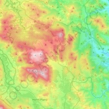
Name: Boletice topographic map, elevation, terrain.
Average elevation: 2,661 ft
Minimum elevation: 1,804 ft
Maximum elevation: 4,029 ft
Thank you for supporting this site ❤️
Make a donation
Make a donation
Gear up for your next adventure:
As an Amazon Associate, this site earns from qualifying purchases at no extra cost to you.
Other topographic maps
Click on a map to view its topography, its elevation and its terrain.
Rakovické Chalupy
Czechia > Southwest > Jihočeský kraj > Mirotice > Rakovické Chalupy
Average elevation: 1,450 ft
Climbing terrain Jickovice
Czechia > Southwest > Jihočeský kraj > Jickovice
Average elevation: 1,358 ft