Geolocate

Ampel topographic map

Click on the map to display elevation.

About this map

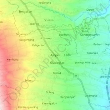
Name: Ampel topographic map, elevation, terrain.

Location: Ampel, Boyolali, Central Java, Java, 57352, Indonesia (-7.49192 110.50359 -7.41192 110.58359)

Average elevation: 2,300 ft

Minimum elevation: 1,581 ft

Maximum elevation: 3,586 ft

Other topographic maps

Click on a map to view its topography, its elevation and its terrain.

Cepogo

Indonesia > Central Java > Boyolali

Average elevation: 4,291 ft

Cluntang

Indonesia > Central Java > Boyolali

Average elevation: 3,389 ft

Gear up for your next adventure:

👟Trail Running Shoes - Lightweight shoes for trail runners
🌎3D Topographic Globes - Raised relief globes for a tactile understanding of geography
🔥Plasma Lighters - Windproof lighters that work in any weather condition
🦶Carbon Trekking Poles - Reduce knee impact on steep descents with ultra-light poles
📚Navigation Handbooks - Master the art of reading topographic maps and using a compass

As an Amazon Associate, this site earns from qualifying purchases at no extra cost to you.