
Thank you for supporting this site ❤️
Make a donation
Make a donation
Gear up for your next adventure:
As an Amazon Associate, this site earns from qualifying purchases at no extra cost to you.
Việt Quang topographic map
Click on the map to display elevation.
Thank you for supporting this site ❤️
Make a donation
Make a donation
Gear up for your next adventure:
As an Amazon Associate, this site earns from qualifying purchases at no extra cost to you.
About this map
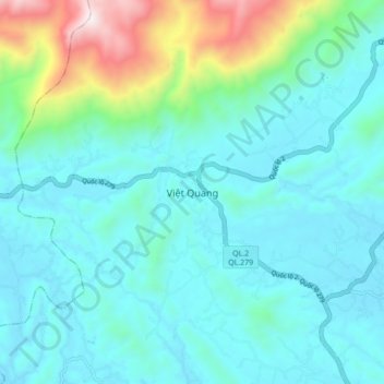
Name: Việt Quang topographic map, elevation, terrain.
Location: Việt Quang, Bắc Quang District, Hà Giang Province, Vietnam (22.37190 104.76612 22.45190 104.84612)
Average elevation: 843 ft
Minimum elevation: 190 ft
Maximum elevation: 3,819 ft
Thank you for supporting this site ❤️
Make a donation
Make a donation
Gear up for your next adventure:
As an Amazon Associate, this site earns from qualifying purchases at no extra cost to you.