
Make a donation
Gear up for your next adventure:
As an Amazon Associate, this site earns from qualifying purchases at no extra cost to you.
Beni Maouche topographic map
Click on the map to display elevation.
Make a donation
Gear up for your next adventure:
As an Amazon Associate, this site earns from qualifying purchases at no extra cost to you.
Beni Maouche
Le territoire de la commune étant d’une manière générale constitué d’un relief accidenté dont les creux et les monts sont très prononcés représentant des crêtes le long desquels sont fondés des villages. Le point culminant est Achtoug 1 392 m d'altitude, l'ancien village Othronen 1 136 m, ath kheyar avec 1 054 m d’altitude, Tizekht 872 m, Aguemoune 810 m, ath adjissa 843 m, tiwal 600 m, et laazib sidi sadek 470 m.
Make a donation
Gear up for your next adventure:
As an Amazon Associate, this site earns from qualifying purchases at no extra cost to you.
About this map
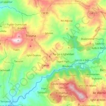
Name: Beni Maouche topographic map, elevation, terrain.
Location: Beni Maouche, Daïra Beni Maouche, Béjaïa, 06024, Algérie (36.43204 4.71602 36.54394 4.86577)
Average elevation: 2,352 ft
Minimum elevation: 971 ft
Maximum elevation: 4,485 ft
Make a donation
Gear up for your next adventure:
As an Amazon Associate, this site earns from qualifying purchases at no extra cost to you.
Other topographic maps
Click on a map to view its topography, its elevation and its terrain.