Geolocate

Searcy topographic map

Click on the map to display elevation.

About this map

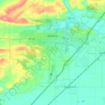
Name: Searcy topographic map, elevation, terrain.

Location: Searcy, White County, Arkansas, United States (35.19499 -91.80108 35.26953 -91.66087)

Average elevation: 276 ft

Minimum elevation: 190 ft

Maximum elevation: 518 ft

White County trails, hiking, mountain biking, running and outdoor activities

Other topographic maps

Click on a map to view its topography, its elevation and its terrain.

Romance

United States > Arkansas > White County

Average elevation: 630 ft

Gear up for your next adventure:

GPS Sports Watch - GPS watch for running, hiking and training
🛡️Insect Repellent - Protection against bugs during outdoor activities
🧷Carabiner Set - Durable clips for gear attachment
🏕️Tent Footprint - Protect your tent base from wear
🧯Portable Fire Pit - Compact fire pit for camping spots

As an Amazon Associate, this site earns from qualifying purchases at no extra cost to you.