
Thank you for supporting this site ❤️
Make a donation
Make a donation
Gear up for your next adventure:
As an Amazon Associate, this site earns from qualifying purchases at no extra cost to you.
Sibi topographic map
Click on the map to display elevation.
Thank you for supporting this site ❤️
Make a donation
Make a donation
Gear up for your next adventure:
As an Amazon Associate, this site earns from qualifying purchases at no extra cost to you.
About this map
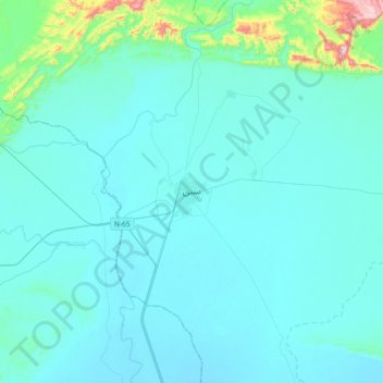
Name: Sibi topographic map, elevation, terrain.
Location: Sibi, Sibi Tehsil, Sibi District, Balochistan, 82000, Pakistan (29.39001 67.72334 29.71001 68.04334)
Average elevation: 558 ft
Minimum elevation: 387 ft
Maximum elevation: 2,431 ft
Thank you for supporting this site ❤️
Make a donation
Make a donation
Gear up for your next adventure:
As an Amazon Associate, this site earns from qualifying purchases at no extra cost to you.