
Make a donation
Gear up for your next adventure:
As an Amazon Associate, this site earns from qualifying purchases at no extra cost to you.
Boračko jezero topographic map
Click on the map to display elevation.
Make a donation
Gear up for your next adventure:
As an Amazon Associate, this site earns from qualifying purchases at no extra cost to you.
Boračko jezero
It lies at the northeastern foot of the mountain Prenj, at an altitude 397 m. From the west it is surrounded by steep forested mountain slopes of Crna Gora (Black Mountain, 1343 m), and from the east by Tranjine (1055 m). The lake basin was created in the Boračka draga, during the expansive process of glacial erosion.
Make a donation
Gear up for your next adventure:
As an Amazon Associate, this site earns from qualifying purchases at no extra cost to you.
About this map
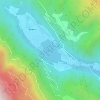
Name: Boračko jezero topographic map, elevation, terrain.
Average elevation: 2,185 ft
Minimum elevation: 1,289 ft
Maximum elevation: 4,669 ft
Make a donation
Gear up for your next adventure:
As an Amazon Associate, this site earns from qualifying purchases at no extra cost to you.