
Make a donation
Gear up for your next adventure:
As an Amazon Associate, this site earns from qualifying purchases at no extra cost to you.
Groß Vollstedt topographic map
Click on the map to display elevation.
Make a donation
Gear up for your next adventure:
As an Amazon Associate, this site earns from qualifying purchases at no extra cost to you.
About this map
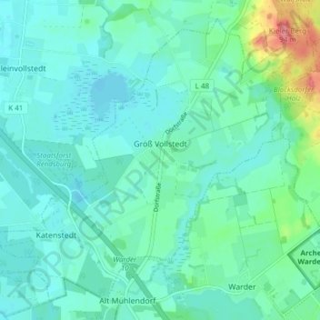
Name: Groß Vollstedt topographic map, elevation, terrain.
Average elevation: 85 ft
Minimum elevation: 39 ft
Maximum elevation: 279 ft
Make a donation
Gear up for your next adventure:
As an Amazon Associate, this site earns from qualifying purchases at no extra cost to you.
Other topographic maps
Click on a map to view its topography, its elevation and its terrain.
Make a donation
Gear up for your next adventure:
As an Amazon Associate, this site earns from qualifying purchases at no extra cost to you.
Schülp
Deutschland > Schleswig-Holstein > Rendsburg-Eckernförde > Schülp bei Rendsburg
Average elevation: 16 ft
Make a donation
Gear up for your next adventure:
As an Amazon Associate, this site earns from qualifying purchases at no extra cost to you.
Kopperpahl
Deutschland > Schleswig-Holstein > Rendsburg-Eckernförde > Kronshagen > Kopperpahl
Average elevation: 69 ft
Nortorf
Deutschland > Schleswig-Holstein > Rendsburg-Eckernförde > Nortorf > Nortorf
Average elevation: 82 ft
Büdelsdorf
Deutschland > Schleswig-Holstein > Rendsburg-Eckernförde > Büdelsdorf > Büdelsdorf
Average elevation: 33 ft
Hanerau-Hademarschen
Deutschland > Schleswig-Holstein > Rendsburg-Eckernförde
Average elevation: 92 ft
Make a donation
Gear up for your next adventure:
As an Amazon Associate, this site earns from qualifying purchases at no extra cost to you.
Holtdorf
Deutschland > Schleswig-Holstein > Rendsburg-Eckernförde > Bargstedt
Average elevation: 115 ft
Kronsburg
Deutschland > Schleswig-Holstein > Rendsburg-Eckernförde > Bredenbek
Average elevation: 56 ft
Lurup
Deutschland > Schleswig-Holstein > Rendsburg-Eckernförde > Elsdorf-Westermühlen
Average elevation: 46 ft
Schweineweide
Deutschland > Schleswig-Holstein > Rendsburg-Eckernförde > Damp
Average elevation: 13 ft
Make a donation
Gear up for your next adventure:
As an Amazon Associate, this site earns from qualifying purchases at no extra cost to you.
Domsland
Deutschland > Schleswig-Holstein > Rendsburg-Eckernförde > Eckernförde
Average elevation: 69 ft
Klein Nordsee
Deutschland > Schleswig-Holstein > Rendsburg-Eckernförde > Felde
Average elevation: 46 ft
Make a donation
Gear up for your next adventure:
As an Amazon Associate, this site earns from qualifying purchases at no extra cost to you.
Make a donation
Gear up for your next adventure:
As an Amazon Associate, this site earns from qualifying purchases at no extra cost to you.
Make a donation
Gear up for your next adventure:
As an Amazon Associate, this site earns from qualifying purchases at no extra cost to you.
Make a donation
Gear up for your next adventure:
As an Amazon Associate, this site earns from qualifying purchases at no extra cost to you.
Hohenhain
Deutschland > Schleswig-Holstein > Rendsburg-Eckernförde > Schwedeneck
Average elevation: 66 ft
Make a donation
Gear up for your next adventure:
As an Amazon Associate, this site earns from qualifying purchases at no extra cost to you.
Hörst
Deutschland > Schleswig-Holstein > Rendsburg-Eckernförde > Rieseby > Hörst
Average elevation: 89 ft
Make a donation
Gear up for your next adventure:
As an Amazon Associate, this site earns from qualifying purchases at no extra cost to you.
Kronshagen
Deutschland > Schleswig-Holstein > Rendsburg-Eckernförde > Kronshagen > Kronshagen
Average elevation: 72 ft
Bargfeld
Deutschland > Schleswig-Holstein > Rendsburg-Eckernförde > Bargfeld
Average elevation: 102 ft
Make a donation
Gear up for your next adventure:
As an Amazon Associate, this site earns from qualifying purchases at no extra cost to you.