Geolocate

Tomahawk topographic map

Click on the map to display elevation.

About this map

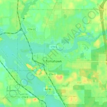
Name: Tomahawk topographic map, elevation, terrain.

Location: Tomahawk, Lincoln County, Wisconsin, United States (45.44980 -89.76236 45.49980 -89.68790)

Average elevation: 1,453 ft

Minimum elevation: 1,414 ft

Maximum elevation: 1,509 ft

Lincoln County trails, hiking, mountain biking, running and outdoor activities

Other topographic maps

Click on a map to view its topography, its elevation and its terrain.

Chicago Island

United States > Wisconsin > Lincoln County > Tomahawk

Average elevation: 1,447 ft

Irma

United States > Wisconsin > Lincoln County

Average elevation: 1,526 ft

Gleason

United States > Wisconsin > Lincoln County > Town of Russell

Average elevation: 1,460 ft

Dudley

United States > Wisconsin > Lincoln County

Average elevation: 1,516 ft

Gear up for your next adventure:

🪶LED Camping Lantern - Bright lantern for camp lighting
📶Vehicle Signal Boosters - Improve reception in rural areas while driving to trailheads
🧭Compass with Lanyard - Easy‑carry compass for navigation
💧Water Filtration Bottles - Safely drink from streams and lakes while exploring
🛡️Bear Spray Outdoor - Protection in bear country hikes

As an Amazon Associate, this site earns from qualifying purchases at no extra cost to you.