
Make a donation
Gear up for your next adventure:
As an Amazon Associate, this site earns from qualifying purchases at no extra cost to you.
Weinfelden topographic map
Click on the map to display elevation.
Make a donation
Gear up for your next adventure:
As an Amazon Associate, this site earns from qualifying purchases at no extra cost to you.
Weinfelden
Seit Frühjahr 2016 führt der «Weinfelder Weinweg» durch die Weinberge. Die Route des dreistündigen Weinlehrpfads führt vom Bahnhof Weinfelden durch den Ort und dann auf einer Anhöhe am Waldrand entlang bis Ottoberg und im Tal über Boltshausen zurück nach Weinfelden. Entlang des Weges informieren Infotafeln über Rebentwicklung, Rebsorten, Weinbereitung und Winzer. Weitere Höhepunkte sind ein Weinsafe und Kunstinstallationen verschiedener Künstler.
Make a donation
Gear up for your next adventure:
As an Amazon Associate, this site earns from qualifying purchases at no extra cost to you.
About this map
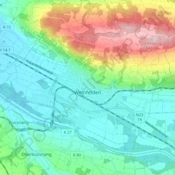
Name: Weinfelden topographic map, elevation, terrain.
Location: Weinfelden, Bezirk Weinfelden, Thurgau, 8570, Schweiz (47.54870 9.06991 47.58781 9.14599)
Average elevation: 1,621 ft
Minimum elevation: 1,362 ft
Maximum elevation: 2,274 ft
Make a donation
Gear up for your next adventure:
As an Amazon Associate, this site earns from qualifying purchases at no extra cost to you.
Other topographic maps
Click on a map to view its topography, its elevation and its terrain.
Make a donation
Gear up for your next adventure:
As an Amazon Associate, this site earns from qualifying purchases at no extra cost to you.