
Make a donation
Gear up for your next adventure:
As an Amazon Associate, this site earns from qualifying purchases at no extra cost to you.
Hezingen topographic map
Click on the map to display elevation.
Make a donation
Gear up for your next adventure:
As an Amazon Associate, this site earns from qualifying purchases at no extra cost to you.
Hezingen
De plaats Hezingen wordt voor het eerst genoemd in een oorkonde van 799, waarbij Oodhelm, zoon van Oodwerc, aan de door Liudger naar Wichmond (bij Zutphen) gebrachte relieken een aantal hoeven schenkt, onder meer een hoeve te 'Hasungen' (Hezingen) en een 'selihova' (zaalhoeve) in 'Manheri' (Mander), ‘in pago Norht Tueanti’. De zaalhoeve in Mander is mogelijk de opgegraven uitzonderlijke boerderij met sacrale ruimte die is gevonden bij archeologisch onderzoek ter hoogte van Vasse - De Steenbrei.
Make a donation
Gear up for your next adventure:
As an Amazon Associate, this site earns from qualifying purchases at no extra cost to you.
About this map
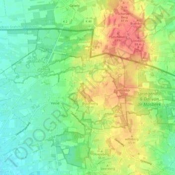
Name: Hezingen topographic map, elevation, terrain.
Location: Hezingen, Tubbergen, Overijssel, Nederland (52.42706 6.84835 52.45136 6.94922)
Average elevation: 157 ft
Minimum elevation: 69 ft
Maximum elevation: 292 ft
Make a donation
Gear up for your next adventure:
As an Amazon Associate, this site earns from qualifying purchases at no extra cost to you.
Other topographic maps
Click on a map to view its topography, its elevation and its terrain.
Make a donation
Gear up for your next adventure:
As an Amazon Associate, this site earns from qualifying purchases at no extra cost to you.
Make a donation
Gear up for your next adventure:
As an Amazon Associate, this site earns from qualifying purchases at no extra cost to you.
Make a donation
Gear up for your next adventure:
As an Amazon Associate, this site earns from qualifying purchases at no extra cost to you.
Make a donation
Gear up for your next adventure:
As an Amazon Associate, this site earns from qualifying purchases at no extra cost to you.
Enschede
Nederland > Overijssel > Enschede
Toen Enschede in 1325 stadsrechten kreeg, verleende de bisschop van Utrecht ook het recht om de nederzetting te versterken. Voor 1325 was Enschede echter al omgeven door een gracht, de zogenaamde Stadsgraven. De twee bruggen over die gracht, de Veldbrug (in de huidige Marktstraat) en de Esbrug (in de…
Average elevation: 112 ft