
Thank you for supporting this site ❤️
Make a donation
Make a donation
Gear up for your next adventure:
As an Amazon Associate, this site earns from qualifying purchases at no extra cost to you.
Goja topographic map
Click on the map to display elevation.
Thank you for supporting this site ❤️
Make a donation
Make a donation
Gear up for your next adventure:
As an Amazon Associate, this site earns from qualifying purchases at no extra cost to you.
About this map
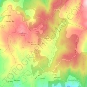
Name: Goja topographic map, elevation, terrain.
Location: Goja, Vila Maior, São Pedro do Sul, Viseu, 3660-229, Portugal (40.76650 -8.04135 40.80650 -8.00135)
Average elevation: 1,453 ft
Minimum elevation: 771 ft
Maximum elevation: 1,946 ft
Thank you for supporting this site ❤️
Make a donation
Make a donation
Gear up for your next adventure:
As an Amazon Associate, this site earns from qualifying purchases at no extra cost to you.