
Make a donation
Gear up for your next adventure:
As an Amazon Associate, this site earns from qualifying purchases at no extra cost to you.
Blekinge County topographic map
Click on the map to display elevation.
Make a donation
Gear up for your next adventure:
As an Amazon Associate, this site earns from qualifying purchases at no extra cost to you.
About this map
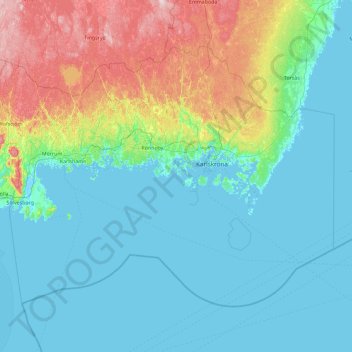
Name: Blekinge County topographic map, elevation, terrain.
Location: Blekinge County, Sweden (55.74669 14.39016 56.50351 16.22367)
Average elevation: 125 ft
Minimum elevation: -10 ft
Maximum elevation: 666 ft
Make a donation
Gear up for your next adventure:
As an Amazon Associate, this site earns from qualifying purchases at no extra cost to you.
Other topographic maps
Click on a map to view its topography, its elevation and its terrain.
Make a donation
Gear up for your next adventure:
As an Amazon Associate, this site earns from qualifying purchases at no extra cost to you.
Karlskrona
When the city was founded in 1680, it was primarily thought of as a military city, with many defenses and fortifications exploiting the particular topography of the city. Some fortifications were located on the main island (Trossö) such as the Bastion Aurora, built at the beginning of the 18th century, but…
Average elevation: 82 ft
Make a donation
Gear up for your next adventure:
As an Amazon Associate, this site earns from qualifying purchases at no extra cost to you.