
Make a donation
Gear up for your next adventure:
As an Amazon Associate, this site earns from qualifying purchases at no extra cost to you.
Nelson Lagoon topographic map
Click on the map to display elevation.
Make a donation
Gear up for your next adventure:
As an Amazon Associate, this site earns from qualifying purchases at no extra cost to you.
About this map
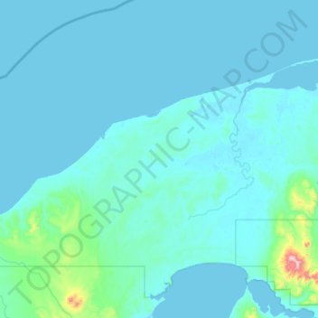
Name: Nelson Lagoon topographic map, elevation, terrain.
Location: Nelson Lagoon, Aleutians East, Alaska, United States (55.62166 -161.85690 56.03140 -160.80695)
Average elevation: 151 ft
Minimum elevation: -3 ft
Maximum elevation: 4,249 ft
Aleutians East trails, hiking, mountain biking, running and outdoor activities
Make a donation
Gear up for your next adventure:
As an Amazon Associate, this site earns from qualifying purchases at no extra cost to you.
Other topographic maps
Click on a map to view its topography, its elevation and its terrain.
Make a donation
Gear up for your next adventure:
As an Amazon Associate, this site earns from qualifying purchases at no extra cost to you.
Unga
United States > Alaska > Aleutians East
55°11′03″N 160°30′18″W / 55.18417°N 160.50500°W / 55.18417; -160.50500 Unga (Unangam tunuu: Uĝnaasaqax̂) is a ghost town on Unga Island in the Aleutians East Borough of the U.S. state of Alaska, about two miles west of Sand Point. The island's length is 15 miles (24 km). Unga's altitude is 59 feet (18 m).
Average elevation: 184 ft