
Make a donation
Gear up for your next adventure:
As an Amazon Associate, this site earns from qualifying purchases at no extra cost to you.
Westerhorn topographic map
Click on the map to display elevation.
Make a donation
Gear up for your next adventure:
As an Amazon Associate, this site earns from qualifying purchases at no extra cost to you.
About this map
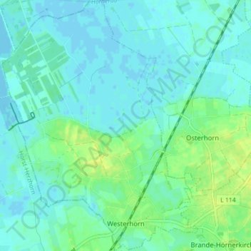
Name: Westerhorn topographic map, elevation, terrain.
Average elevation: 16 ft
Minimum elevation: -10 ft
Maximum elevation: 49 ft
Make a donation
Gear up for your next adventure:
As an Amazon Associate, this site earns from qualifying purchases at no extra cost to you.
Other topographic maps
Click on a map to view its topography, its elevation and its terrain.
Liether Kalkgrube
Deutschland > Schleswig-Holstein > Kreis Pinneberg > Klein Nordende
Average elevation: 46 ft
Tävsmoor/Haselauer Moor
Deutschland > Schleswig-Holstein > Kreis Pinneberg > Appen
Average elevation: 30 ft
Make a donation
Gear up for your next adventure:
As an Amazon Associate, this site earns from qualifying purchases at no extra cost to you.
Stadtpark Lieth
Deutschland > Schleswig-Holstein > Kreis Pinneberg > Elmshorn
Average elevation: 26 ft
Sparrieshoop
Deutschland > Schleswig-Holstein > Kreis Pinneberg > Klein Offenseth-Sparrieshoop
Average elevation: 26 ft