
Make a donation
Gear up for your next adventure:
As an Amazon Associate, this site earns from qualifying purchases at no extra cost to you.
Park Hill topographic map
Click on the map to display elevation.
Make a donation
Gear up for your next adventure:
As an Amazon Associate, this site earns from qualifying purchases at no extra cost to you.
About this map
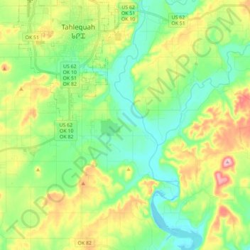
Name: Park Hill topographic map, elevation, terrain.
Location: Park Hill, Cherokee County, Oklahoma, United States (35.79820 -95.03853 35.92610 -94.86423)
Average elevation: 830 ft
Minimum elevation: 630 ft
Maximum elevation: 1,211 ft
Cherokee County trails, hiking, mountain biking, running and outdoor activities
Make a donation
Gear up for your next adventure:
As an Amazon Associate, this site earns from qualifying purchases at no extra cost to you.
Other topographic maps
Click on a map to view its topography, its elevation and its terrain.
Tahlequah
United States > Oklahoma > Cherokee County > Tahlequah > Tahlequah
Average elevation: 856 ft
Make a donation
Gear up for your next adventure:
As an Amazon Associate, this site earns from qualifying purchases at no extra cost to you.
Cookson Hills State Game Refuge
United States > Oklahoma > Cherokee County
Average elevation: 1,106 ft