
Make a donation
Gear up for your next adventure:
As an Amazon Associate, this site earns from qualifying purchases at no extra cost to you.
Bivona topographic map
Click on the map to display elevation.
Make a donation
Gear up for your next adventure:
As an Amazon Associate, this site earns from qualifying purchases at no extra cost to you.
About this map
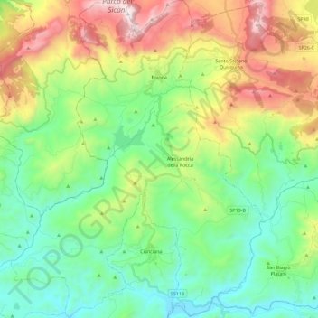
Name: Bivona topographic map, elevation, terrain.
Location: Bivona, Agrigento, Sicily, 92010, Italy (37.48236 13.33472 37.66069 13.46514)
Average elevation: 1,650 ft
Minimum elevation: 180 ft
Maximum elevation: 4,682 ft
Make a donation
Gear up for your next adventure:
As an Amazon Associate, this site earns from qualifying purchases at no extra cost to you.
Other topographic maps
Click on a map to view its topography, its elevation and its terrain.
Monte Rose
Italy > Sicily > Agrigento > Bivona
Monte delle Rose is a mountain in the Monti Sicani, in Sicily, southern Italy. It has an elevation of 1,426 metres (4,678 ft).[1]
Average elevation: 3,763 ft