
Make a donation
Gear up for your next adventure:
As an Amazon Associate, this site earns from qualifying purchases at no extra cost to you.
Junedale topographic map
Click on the map to display elevation.
Make a donation
Gear up for your next adventure:
As an Amazon Associate, this site earns from qualifying purchases at no extra cost to you.
About this map
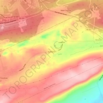
Name: Junedale topographic map, elevation, terrain.
Average elevation: 1,706 ft
Minimum elevation: 1,260 ft
Maximum elevation: 1,909 ft
Carbon County trails, hiking, mountain biking, running and outdoor activities
Make a donation
Gear up for your next adventure:
As an Amazon Associate, this site earns from qualifying purchases at no extra cost to you.
Other topographic maps
Click on a map to view its topography, its elevation and its terrain.
Tresckow
United States > Pennsylvania > Carbon County > Banks Township > Tresckow
Tresckow is located in the western corner of Carbon County at 40°54′56″N 75°57′50″W / 40.91556°N 75.96389°W / 40.91556; -75.96389 (40.915631, -75.963881), at an elevation of 1,778 feet (542 m) on a hill lying between Spring Mountain to the south and Pismire Ridge to the north. The city of…
Average elevation: 1,755 ft