
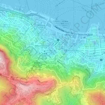
Hong Kong Park topographic map
Interactive map
Click on the map to display elevation.
About this map
Name: Hong Kong Park topographic map, elevation, terrain.
Average elevation: 469 ft
Minimum elevation: -10 ft
Maximum elevation: 1,614 ft
Other topographic maps
Click on a map to view its topography, its elevation and its terrain.
Pok Fu Lam Country Park
Pok Fu Lam Country Park, Lugard Road, Mid-levels, Hong Kong, Central and Western District, Hong Kong, CENTRAL, PRC
Average elevation: 607 ft
Lung Fu Shan
Lung Fu Shan, Hong Kong, Central and Western District, Hong Kong, 1F, PRC
Average elevation: 446 ft
Pak Tsz Lane Park
Pak Tsz Lane Park, Admiralty, Sheung Wan, Hong Kong, Central and Western District, Hong Kong, PRC
Average elevation: 371 ft
Blake Garden
Blake Garden, Admiralty, Mid-levels, Hong Kong, Central and Western District, Hong Kong, PRC
Average elevation: 381 ft
Tamar Park
Tamar Park, Admiralty, Central District, Hong Kong, Central and Western District, Hong Kong, PRC
Average elevation: 262 ft
Cheung Kong Park
Cheung Kong Park, Cheung Kong Center, Central District, Hong Kong, Central and Western District, Hong Kong, PRC
Average elevation: 433 ft