
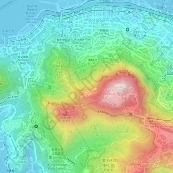
Pok Fu Lam Country Park topographic map
Interactive map
Click on the map to display elevation.
About this map
Name: Pok Fu Lam Country Park topographic map, elevation, terrain.
Average elevation: 607 ft
Minimum elevation: -7 ft
Maximum elevation: 1,752 ft
Other topographic maps
Click on a map to view its topography, its elevation and its terrain.
Hong Kong Park
Hong Kong Park, 19, Admiralty, Central District, Hong Kong, Central and Western District, Hong Kong, PRC
Average elevation: 469 ft
Lung Fu Shan
Lung Fu Shan, Hong Kong, Central and Western District, Hong Kong, 1F, PRC
Average elevation: 446 ft
Pak Tsz Lane Park
Pak Tsz Lane Park, Admiralty, Sheung Wan, Hong Kong, Central and Western District, Hong Kong, PRC
Average elevation: 371 ft
Blake Garden
Blake Garden, Admiralty, Mid-levels, Hong Kong, Central and Western District, Hong Kong, PRC
Average elevation: 381 ft
Tamar Park
Tamar Park, Admiralty, Central District, Hong Kong, Central and Western District, Hong Kong, PRC
Average elevation: 262 ft
Cheung Kong Park
Cheung Kong Park, Cheung Kong Center, Central District, Hong Kong, Central and Western District, Hong Kong, PRC
Average elevation: 433 ft