
Make a donation
Gear up for your next adventure:
As an Amazon Associate, this site earns from qualifying purchases at no extra cost to you.
Ebmatingen topographic map
Click on the map to display elevation.
Make a donation
Gear up for your next adventure:
As an Amazon Associate, this site earns from qualifying purchases at no extra cost to you.
About this map
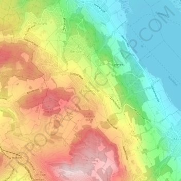
Name: Ebmatingen topographic map, elevation, terrain.
Location: Ebmatingen, Maur, Bezirk Uster, Zürich, 8123, Schweiz (47.33099 8.62070 47.37099 8.66070)
Average elevation: 1,900 ft
Minimum elevation: 1,414 ft
Maximum elevation: 2,461 ft
Make a donation
Gear up for your next adventure:
As an Amazon Associate, this site earns from qualifying purchases at no extra cost to you.
Other topographic maps
Click on a map to view its topography, its elevation and its terrain.
Volketswil
Schweiz > Zürich > Bezirk Uster
Das Dorf Volketswil fügt sich ein zwischen die zwei Moränenhügel Hutzlen und Homberg, die durch den Linthgletscher entstanden sind. In Richtung Hegnau-Dammboden Zimikon ist die Landschaft leicht abfallend. Hegnau ist ein typisches Strassendorf: Das Strassen-Trassee der Nationalstrasse…
Average elevation: 1,624 ft
Make a donation
Gear up for your next adventure:
As an Amazon Associate, this site earns from qualifying purchases at no extra cost to you.