
Make a donation
Gear up for your next adventure:
As an Amazon Associate, this site earns from qualifying purchases at no extra cost to you.
Guayas topographic map
Click on the map to display elevation.
Make a donation
Gear up for your next adventure:
As an Amazon Associate, this site earns from qualifying purchases at no extra cost to you.
Guayas
Guayas' natural terrain is very diverse. The province has no elevations, except for the Coastal Range, which starts in Guayaquil and goes to Manabí. The areas west of the Coastal Range are desertic, with an average temperature of 23 °C. The areas east of the range belong to the Guayas Watershed. They are quite humid and fertile, especially in the north of the province, with an average temperature of 30 °C in the humid season (December–May) and 25 °C in the dry season (June–November).
Make a donation
Gear up for your next adventure:
As an Amazon Associate, this site earns from qualifying purchases at no extra cost to you.
About this map
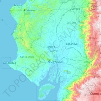
Name: Guayas topographic map, elevation, terrain.
Location: Guayas, Ecuador (-3.06426 -80.56330 -0.83665 -79.09809)
Average elevation: 1,703 ft
Minimum elevation: -10 ft
Maximum elevation: 14,646 ft
Make a donation
Gear up for your next adventure:
As an Amazon Associate, this site earns from qualifying purchases at no extra cost to you.
Other topographic maps
Click on a map to view its topography, its elevation and its terrain.