
Make a donation
Gear up for your next adventure:
As an Amazon Associate, this site earns from qualifying purchases at no extra cost to you.
Duras topographic map
Click on the map to display elevation.
Make a donation
Gear up for your next adventure:
As an Amazon Associate, this site earns from qualifying purchases at no extra cost to you.
Duras
Duras ligt in Vochtig-Haspengouw op een hoogte van omstreeks 45 meter. De Molenbeek stroomt over het grondgebied van Duras. Het landschap wordt beheerst door het Kasteeldomein van Duras, met bossen, parken en dreven. Voorts is er landbouw, waaronder fruitteelt. Direct over de provinciegrens, in de gemeente Zoutleeuw, bevindt zich natuurgebied Het Vinne.
Make a donation
Gear up for your next adventure:
As an Amazon Associate, this site earns from qualifying purchases at no extra cost to you.
About this map
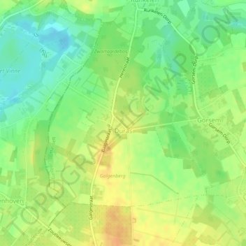
Name: Duras topographic map, elevation, terrain.
Location: Duras, Sint-Truiden, Hasselt, Limburg, België (50.82504 5.13455 50.84336 5.16363)
Average elevation: 121 ft
Minimum elevation: 66 ft
Maximum elevation: 174 ft
Make a donation
Gear up for your next adventure:
As an Amazon Associate, this site earns from qualifying purchases at no extra cost to you.
Other topographic maps
Click on a map to view its topography, its elevation and its terrain.
Make a donation
Gear up for your next adventure:
As an Amazon Associate, this site earns from qualifying purchases at no extra cost to you.
Make a donation
Gear up for your next adventure:
As an Amazon Associate, this site earns from qualifying purchases at no extra cost to you.